Fun Trail Facts
In 2011, Jesse Coombs successfully kayaked the 96-foot drop at Abiqua Falls. Kids, don't try this at home! Coombs is a professional and still suffered a fractured shoulder socket and a collapsed lung.
Trail Info
| Hike/Section Name Abiqua Falls County & State Marion County, Oregon Ecoregion Cascades | Western Cascades Montane Highlands Forest Santiam State Forest Latitude & Longitude (DEC) 44.9263208, -122.5672886 Family Friendliness Really tough, but doable with my 4-year-old Hike Difficulty Moderate [some steeper ascents and descents, challenging terrain in parts of the trail] Elevation 1,264 Feet Elevation Gain ~200 Feet Distance ~ 1 Mile Route Type Out and Back Access to Trailhead Brutally rough gravel road, NOT recommended for passenger cars that you care about |
Trip Report
Abiqua Falls was one of those places that I read about again and again during my research of waterfalls around the Santiam State Forest, and it always left me wanting to make my way there. Noted as a tough place to reach, it wasn't until this past weekend that the boy and I went for it and threw caution to the wind.
With noon approaching on a Saturday afternoon, it was time to scramble and collect our gear. Everything was in order. I just wish the same could have been said for most every other decision I made afterward.
I rarely depend on Google Maps or GPS for directions to trailheads, but for some insane reason I chose this trip to begin with such a folly. The directions landed us on some logged mountainsides' forest roads, and we decided that some some wandering around on the nearby land was in order. According to the GPS, we were 1.3 kilometers away from Abiqua Falls, just on the bloody wrong side of the canyon. Trotting through that much private land and terrain changes has no appeal to me, so we took pictures of our current situation, took a few moments of silence around a roadside memorial, and returned to the car.
Whipping the car back down to Silverton and over to Scotts Mills, we hit a favorite road of ours, Crooked Finger Road, and followed the directions I should have utilized in the first place. After the pavement ended and we took the right at CF300, the road got a little rough as we cruised downhill.
I read multiple trip reports of people who said that the road down to Abiqua Falls could be traversed by a passenger car.
Well, yes, it could be done. That does not imply it should be done, but we did it anyway. That road truly eats passenger cars for breakfast, as evident by the blown out bits of rubber every half-mile or so. Luckily, we made it safely.
I recalled that you walk back from where you park and cruise down the trail. What I conveniently forgot was the part about ignoring the first trail down and taking the second that was 50-100 feet further down the road. With the boy on my shoulders, we began traversing our way straight down the mountainside toward Abiqua Creek. The trail all but ended, and we hung tight with the slope. I never felt worried about the lad's safety during our descent, but my legs were nowhere near as accepting.
At one point, we found a 25-foot clearing that was largely free of rocks and slid down. Remember, I wasn't aware of the second trail at this point and was completely dreading the return up the mountain. "So this is why the hike was listed as not family friendly," I thought to myself, sprinkled with expletives under my breath that nobody but my conscience would hear.
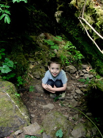
My boy was having a blast throughout all of this. There was only one spot that scared him, and that was when I slipped on a lone rock and drove my knee and elbow into the ground while keeping him stabilized. Despite being shaken up for that brief moment, he was ready to throw rocks into the creek once we were at the water. The moment was taken to wash my wounds and let him skip some stones. A few sips of water, and we were trucking along the creek and heading upstream toward the falls.
My boy was having a blast throughout all of this. There was only one spot that scared him, and that was when I slipped on a lone rock and drove my knee and elbow into the ground while keeping him stabilized. Despite being shaken up for that brief moment, he was ready to throw rocks into the creek once we were at the water. The moment was taken to wash my wounds and let him skip some stones. A few sips of water, and we were trucking along the creek and heading upstream toward the falls.
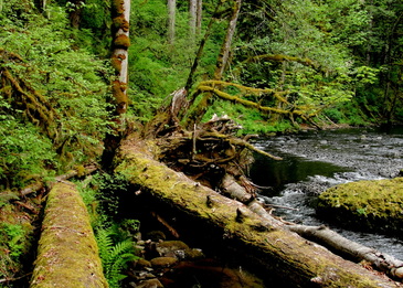
There was absolutely no trail at this point, so we just did our best cruising up and over the fallen trees, boulders, and miscellaneous riparian buffer obstacles. After what felt like a couple thousand feet, we finally hit the actual trail, and it was at this point I noticed the ropes leading back up. My heart sang, and we hadn't even seen the main event. Once we hit the main trail, it was pure fun ducking under or hopping over a couple of trunks.
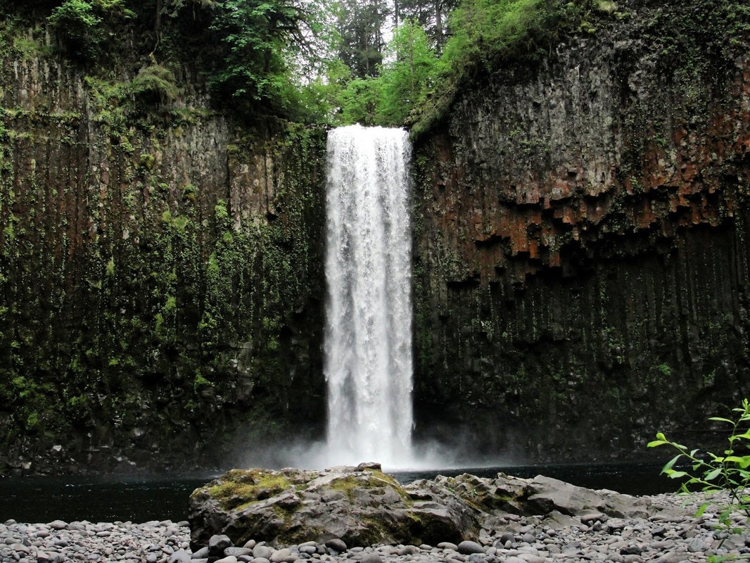
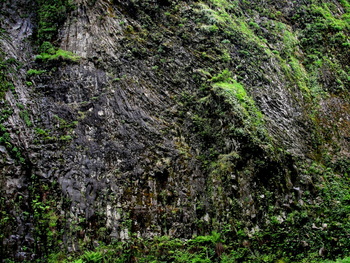
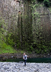
When you hear the falls just ahead, it does not prepare you for the grandeur that awaits. To turn the corner around the creek and land in the most perfect basaltic amphitheater, with Abiqua Falls crashing down in the center, a sense of absolute wonder overtook both of us. I hooted, he hollered. Hours were spent down there, playing with rocks, talking about basaltic columns, algae and moss, erosion, and a million other things that need to be discussed when you're a four-year-old.
When you hear the falls just ahead, it does not prepare you for the grandeur that awaits. To turn the corner around the creek and land in the most perfect basaltic amphitheater, with Abiqua Falls crashing down in the center, a sense of absolute wonder overtook both of us. I hooted, he hollered. Hours were spent down there, playing with rocks, talking about basaltic columns, algae and moss, erosion, and a million other things that need to be discussed when you're a four-year-old.
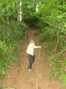
When it was time to go, we stuck to the proper trail and utilized every inch of rope provided by some kind souls for the trek back up. The lad did great for a bit, but did end up back on my shoulders for a good chunk of the climb. He's getting heavier by the day, but this was one of those spots where I wanted him up there safe and sound.
We got back to my car, and the parking area was as empty when we left as it was when we arrived. After making it back over the hellacious road up the mountain without a flat tire or broken suspension, we enjoyed a beautiful drive through the backroads of the valley.
Even with the botched initial directions, boulder-dodging on the road, and poor trail choice on the way down, I would do this again and again the same way if need be. Abiqua Falls may be one of my absolutely favorite spots in all of Oregon now. Many thanks to the Mount Angel Abbey for letting us enjoy such splendor on their land.
 RSS Feed
